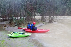
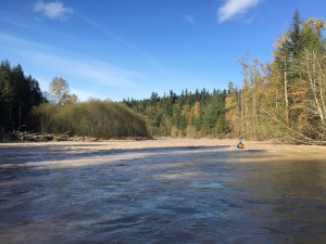
In 2015, the Nisqually River Council (NRC) initiated a project to prepare a plan for the development and management of a water trail on the main stem Nisqually River from below LaGrande Dam to the Nisqually delta. The goal is to facilitate a collaborative planning process inclusive of all landowners along the river and with other stakeholders to develop safe and appropriate public access points to the river for launching and taking out small human powered boats such as rafts, canoes, kayaks and inner tubes.
The development of the water trail supports goals outlined in the NRC’s guiding document, the Nisqually Watershed Stewardship Plan (NWSP). By implementing the NWSP, the NRC and its partners have achieved numerous environmental successes, including the protection of 75% of the Nisqually River mainstem. Additionally, the watershed is home to multiple recreation opportunities; the creation of the Nisqually State Park was called for in the original Nisqually River Management Plan of 1985. Public recreation access to the river, however, is extremely limited and this project seeks to implement the ‘Recreation/Public Access/Tourism’ goals of the NWSP.
Technical planning assistance is being provided to the NRC on this project from the ‘Rivers, Trails and Conservation Assistance’ (RTCA) program of the National Park Service. RTCA awards grants of non-financial planning assistance to government agencies and/or non-profit groups working on local conservation and recreation projects. RTCA is assisting the NRC in defining/managing the planning process and in designing public outreach strategies. For more information go to: www.nps.gov/rtca
 The project is expected to take about 18 months to two years to complete. During this time, staff from the NRC and RTCA will work with a citizen advisory committee to work through a planning process that includes the following components: vision and goal setting; stakeholder analysis and outreach; inventory of existing resources and facilities; issue identification; community and public outreach; identification of opportunities, constraints and management issues; evaluation of alternatives; development of recommendations; identification of potential funding and partnership opportunities; and plan production and adoption.
What is a water Trail? What does it mean?
[expand title=”Water Trail FAQs” rel=”Read More”]
What is a water trail? A water trail is a section of river (or saltwater) that offer non-motorized boaters (like rafts, canoes, rowboats, or kayaks) the opportunity to travel a marked route by providing access areas, environmental and historical points of interest, signage, and picnic stops. They educate on the environment, history, and culture of the area and promote resource stewardship.
Is a water trail like a hiking trail? Kind of. A water trail has places to launch, just like a trailhead is a place to start hiking. Water trail launch points often have parking lots, restrooms, and information signs just like hiking trailheads have. However the river itself serves as the trail and there is no land-based trail along the river.
So is the water trail only for boaters? Not necessarily. Many of the access points are also open people who want to picnic, take pictures or sit by the river. In some places, walking trails do go to the Nisqually River, offering opportunities for land-based recreationists to connect with the water trail.
What are some examples of established water trails? The Willapa Bay Trail (river and bay), the Kitsap Peninsula Water Trail (on Puget Sound), and the Cascadia Marine Trail (Puget Sound and San Juan Islands) are all examples of water trails. The Washington Water Trails Association (www.wwta.org) has information on all these trails and more.
What’s the difference between a river without a water trail and a river with a water trail? It’s the same river. The only difference is that a water trail connects the various access sites along the river that are often owned and managed by various entities. A water trail creates an opportunity to connect these sites with a logo, similar signage, map/guide and website. It also provides opportunities to share safety information and tell the natural and cultural stories of the river.
Why is a water trail proposed for the Nisqually River? Connecting to nature, especially on or near the Nisqually River, is highly valued by many people. Hikers, rafters, photographers and others enjoy the chance to experience a wild river that is protected, unspoiled and natural. Developing a water trail is an opportunity to link these experiences, and to examine opportunities to add new access areas in a way that is compatible with natural and cultural resources. An established water trail is also a way to promote better stewardship of the river. Other examples of water trails have active volunteer groups that host regular trash clean-up events.
What is the Nisqually River Council and who are its members? The Nisqually River Council (NRC) was established in 1987. It is a collaborative group that meets once a month and meetings are open to everyone. The NRC works to promote stewardship and sustainability in the Nisqually Watershed. Members of the NRC include the Nisqually Indian Tribe, state, federal and local agencies, businesses owners from Yelm, Eatonville or Ashford, and people who live in the Nisqually Watershed. A full list of members is available here.
Why is the NRC working on a water trail proposal? The Nisqually Watershed Stewardship Plan (NWSP) is the guiding document of the NRC. The plan focuses on protecting environmental, social and economic values in the watershed. An important concept of the NWSP is the value and abundance of high quality recreation for all people. Even though there are numerous places to hike, public recreation access to the Nisqually River is very limited. This planning project seeks to address the lack of river access by examining opportunities for safe and appropriate access points to the river that complement other goals of the NRC.
What would this plan mean for the Nisqually River through the Nisqually Reservation and protecting cultural resource sites? There would be no access points to the Reservation for non-tribal members. This plan also recommends working with the Tribe to reduce trespassing on Reservation land. Lastly, the NRC hopes to work with the Tribe to develop appropriate interpretation materials sharing the Tribe’s history and current efforts in salmon habitat restoration. All efforts will be taken to protect areas of cultural resources. For example, the area around the Mashel Confluence will remain protected. The plan also recommends that a small day use launch area be built no less than 1/4 mile away from the Ohop Confluence. The site would not allow parking next to the river (with the exception of ADA parking) but would allow better access for boaters, hikers, and other recreationists. The Tribe would be consulted in planning for this site, and all decisions are ultimately to be made by Washington State Parks and the Nisqually Indian Tribe.
What would this plan mean for salmon restoration efforts in the upper Nisqually watershed? The proposal has been developed in consultation with tribal and state biologists to minimize impacts on salmon spawning. The most critical salmon spawning sites (including the Mashel River and Mashel Confluence) will remain protected, even though some of them are also highly desirable boat launch sites as well. The plan is also recommending that river access should not be open during spawning seasons to protect redds.
Why does the plan recommend an open season for the water trail? The upper Nisqually River provides crucial spawning habitat for multiple salmon species, including the threatened Chinook and Steelhead. Under the advice of tribal and state fisheries biologists, this plan attempts to find a balance between environmental integrity and public recreation access. By implementing an open season, this plan will concentrate use around the spawning seasons of threatened salmon. This will reduce negative impacts on the fish while still providing better access to the Nisqually River. The open season would be from November to mid-February (when water flows are most desirable) and from July to mid-August. [/expand]
Resources:
Nisqually River Water Trail Draft Plan
Potential Funding Sources (Appendix 3)
Learn about the planning process